Although most of us associate autumn as peak wildfire season, firefighters and public safety officials prepare for fire events year-round. Whether the result of human negligence or natural disaster, wildfires burned just over 10 million acres in 2020. Environmental, human, and other physical losses severely impact communities and the environment. In the case of large-loss fires, or conflagrations, this destruction is often irreparable. To proactively protect life, property, and natural wildlife habitats, wildfire management officials employ a wide variety of fire detection and monitoring tools.
Early detection by wildfire management organizations increases the likelihood of successfully suppressing a fire before it is beyond control. Unfortunately, forests – where most fires originate – are usually remote and geographically expansive. Areas dense with trees, parched wood, low-moisture soil, and dry leaves compound the already challenging logistics of a forest. These naturally occurring factors create a combustible environment, especially vulnerable to lightning strikes and high temperatures. Even beyond the moment of ignition, known as the ‘surface fire’ stage, these elements act as fuel, spreading wider and higher, becoming a ‘crown fire.’
Human negligence or criminal activity also cause wildfires. In 2020, tens of thousands of acres burned in Australia, decimating homes, businesses, animals, and killing 24 people. Dozens of individuals were arrested for deliberately setting at least 100 fires. Although accidental fires occur from far less malicious activity, the resulting damage is just as devastating. Abandoned cooking grills, campfires, and even something as small as a discarded cigarette butt can turn a dry pile of leaves into a blazing, multi-acre fire.
Wildfire management officials use detection and suppression techniques to contain fires at the earliest stages possible. The most common methods to do this include:
- Satellite imaging
- Controlled burning
- Fire weather forecasts and estimates of fuel and moisture
- Watch towers
- Optical smoke detectors
- Lightning and lightning coordinates detectors
- Infrared
- Remote cameras
- Spotter planes
- Water tankers
- Eyewitness reports via mobile/smart phones, social media, hotlines, etc.
Weather conditions and smoke from a rapidly spreading fire can obscure visibility, rendering most of the items above ineffective. To combat this limitation, officials increasingly deploy unmanned, aerial vehicles (UAVs) and ground based detectors. Drones and sensors can collectively link up as an array of devices “…to form a network of sensors – or an Internet of Things (IoT) – to detect the early signs of fire – namely heat and smoke – with UAVs buzzing above, sucking up data and relaying it to control centers.” ~ AZO Sensors
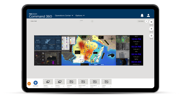
The control centers at the heart of wildfire management provide centralized, regional locations from which to collect, analyze, and report critical data. A visual collaboration platform facilitates monitoring procedures by integrating source devices with high-performance processing, content management, and video processing.
Emergency response to a fast-spreading fire requires real-time situational awareness by first responders. Instant access to a wide range of drone, sensor, satellite, and web-based monitoring tools means greater precision in detecting and predicting fire behavior. Visual intelligence disseminated to multiple agencies simultaneously ensures decisions are made from a single body of data. This forms a common operating picture. Any of these factors may influence whether an abandoned campfire becomes a wildfire, or worse, a conflagration that destroys everything in its path.
Haivision is committed to designing visual intelligence and collaboration systems for control centers that provide innovative, effective solutions for wildfire management teams of all sizes. Contact us today to schedule a demo and learn how our systems support early fire detection, monitoring, and mitigation.
